How Satellite Imagery Reveals Plastic Pollution Hotspots in the Ocean

Garbage Island in the Pacific Ocean near Hawaii. Photo from World Council For Nature
Plastic pollution isn’t just a sad environmental story we scroll past on the news anymore, it has become a personal health emergency. It is a genuinely scary reality that microplastics, those tiny, unseen fragments, have made their way into our lungs and bloodstreams. To grasp the sheer scale of this threat, researchers are turning to Sentinel satellite imagery, utilizing it as an essential “eye in the sky” to track exactly where these hazardous accumulation zones are growing.
But seeing the trash is only step one, we must understand the human toll. Innovative analyses like Poseidon are finally linking ocean pollution to specific public health dangers like endocrine disruption, cardiovascular strain, and toxic accumulation.
Why Traditional Monitoring Is Not Enough
For years we have relied on manual and labor-intensive methods like ship logs, aerial surveys, and towing underwater cameras to spot ocean trash. Yeah, these methods were better than nothing. But still, they are expensive, slow, and leave massive gaps in our knowledge. We just can not monitor remote or dangerous waters continuously.
This is where space technology changes the game. Scientists are now utilizing Earth observation satellites to detect the unique reflected light signature of plastic. It is a difficult task since a single bottle is smaller than a pixel, but when debris aggregates, it becomes visible. So, plastic hotspots off Gabriola Island, Canada, and near Edinburgh, Scotland were identified by because specialists could view and download Sentinel-2 data.
So, what makes the Sentinel satellites the MVPs in this fight? It’s not just that they take photos, it’s how they see the world. Their “superpowers” are perfectly suited for hunting marine litter:
- Spatial Resolution: These satellites can resolve details down to 10 meters. That sharpness is crucial when trying to pick out debris cluttering complex coastlines.
- Revisit Frequency: The satellite doesn’t just snap a picture and leave; it revisits the same spot every few days. This allows us to track the movement of pollution over time, rather than just seeing a static snapshot.
- Spectral Differentiation: This is the real magic trick. The satellite can distinguish between natural items (like seaweed) and artificial plastic based on how they absorb light, effectively reading the material’s “fingerprint” from space.
While these satellites were originally designed for land, this remote sensing provides the hard evidence needed to validate pollution models. However, mapping is just the diagnostic tool; the ultimate cure lies in fixing land-based waste management.
Related: How Can AI Help Clean up Plastics From Our Oceans and Waterways?
How Satellites Detect Floating Plastic Debris
Detecting plastic isn’t as simple as snapping a photo, it is a high-tech puzzle of light and chemistry.
- Optical Imaging: Plastic has a unique “spectral signature”, it reflects sunlight differently than nature does. Using multispectral sensors, researchers can distinguish between:
- Seawater
- Algae and organic vegetation
- Floating plastic fragments
To sort the mess, scientists use the Floating Debris Index (FDI). This tool highlights strange blips on the surface, helping analysts distinguish actual pollution from natural seaweed or sea foam.
- Seeing Through the Noise: Regular cameras have one big enemy: clouds. To beat this, Synthetic Aperture Radar (SAR) satellites, like Sentinel-1, track surface texture rather than color. They work day or night, piercing through clouds to spot the eerie “smoothing” effect plastic patches have on waves. Thermal sensors also help, spotting heat differences since plastic warms up faster than the surrounding ocean.
- The Sentinel-2 Breakthrough: The real game-changer arrived when Dr. Lauren Biermann at the Plymouth Marine Laboratory reimagined how we use Sentinel 2 imagery. She developed a brilliant, counter-intuitive approach using AI algorithms to find what was previously hidden.
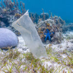
Typically, near-infrared (NIR) analysis is used in precision agriculture to check crop health by looking for the “glow” of chlorophyll (photosynthesis). Dr. Biermann flipped this logic: her algorithm scans the ocean for floating patches that lack this photosynthetic signature. If a patch is floating but isn’t glowing like algae, it is likely inorganic, plastic. This method has been crucial in distinguishing “garbage islands” (like the one near Hawaii) from natural vegetation.
By accurately identifying these hotspots, these satellites now play a dual role: they track the slow-motion disaster of plastic accumulation while also assisting emergency services in assessing damage from rapid human-made disasters.
Related: Could Technology Be the Answer to Saving Our Oceans from Plastic Pollution?
The Great Pacific Garbage Patch: A Moving Target
The Great Pacific Garbage Patch is the grim “poster child” of marine pollution, and for good reason. Spanning a staggering 1.6 million square kilometers between Hawaii and California, roughly three times the size of France, it is a colossus of waste. However, contrary to the popular image of a solid island you can walk on, this patch is often a shifting, treacherous soup of microplastics that is notoriously difficult to map from the deck of a boat.
To understand this phenomenon, researchers rely on the continuous stream of Sentinel images captured from orbit. These views from above have been instrumental in dispelling the myth that the patch is a static object; in reality, it behaves almost like a living organism.
Using the valuable satellite observations scientists can now define the borders of the patch, track the density of debris and even understand how wind patterns and ocean currents force the trash to gather and spread.
Related: River Cleaning Technology: To Clean the Oceans, We Start With Rivers

Future Prospects and Challenges
The technology watching over our oceans is advancing at breakneck speed. We are moving past the days of passive observation into a new era where Artificial Intelligence acts as a global scout, scanning the seas to identify pollution with incredible speed.
However, saving the oceans isn’t just about having the coolest gadgets. There are real roadblocks we have to overcome:
- Speaking the same language: We currently lack global standards, meaning data from one country often can’t be compared to another.
- The price tag: High-end detection gear remains too expensive for developing nations, which, ironically, often face the worst of the pollution crisis.
- Opening the doors: To fix a planetary problem, we must democratize Sentinel data access, ensuring researchers in underfunded regions aren’t locked out of these powerful tools.
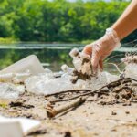
But what’s more important today is the citizen science. You don’t need a PhD to be part of the solution: support the science, push for funding, or simply grab a bag and join a local cleanup. The tools to see the problem are finally here; now we need the hands to fix it.
Related: 3 Simple Steps Logistics Companies Can Take to Reduce Microplastic Pollution
Conclusion: A Clearer View of a Cleaner Future
Satellite imagery has completely revolutionized our ability to monitor the health of our planet’s waters. We have moved past the era of sporadic ship surveys to a time of continuous, global observation. By successfully fusing optical sensors, synthetic aperture radar, and advanced artificial intelligence, researchers can now pinpoint accumulation zones and predict exactly where ocean currents will carry debris next.
The real power of this transition lies in accessibility. Because researchers can leverage Sentinel free data sources, the scientific community can collaborate across borders without the hurdle of prohibitive costs. As orbit technology advances—capturing higher-resolution data more frequently—our understanding of these “plastic highways” will become razor-sharp. Satellite monitoring is far more than a scientific novelty; it is the essential roadmap we need to navigate toward a cleaner, plastic-free ocean.
______________
Author :
Kateryna Sergieieva has a Ph.D. in information technologies and 15 years of experience in remote sensing. She is a scientist responsible for developing technologies for satellite monitoring and surface feature change detection. Kateryna is an author of over 60 scientific publications.
